CORE WALL CONTROL SURVEY INVENTED AT FIRST FOR THE BURJ KHALIFA, DUBAI
The construction of iconic towers such as the 828 meters high Burj Khalifa (formerly Burj Dubai), officially inaugurated on 4th January 2010 in Dubai, poses many challenges to surveyors, engineers and contractors. Tall towers may bend and sway in the wind, with cranes and other loads. Ideally, such motion should centre on the as-designed main axis, so that in the absence of load the tower stands precisely vertical, but deviations occur as a result of raft settlement, concrete shortening and construction tolerances.
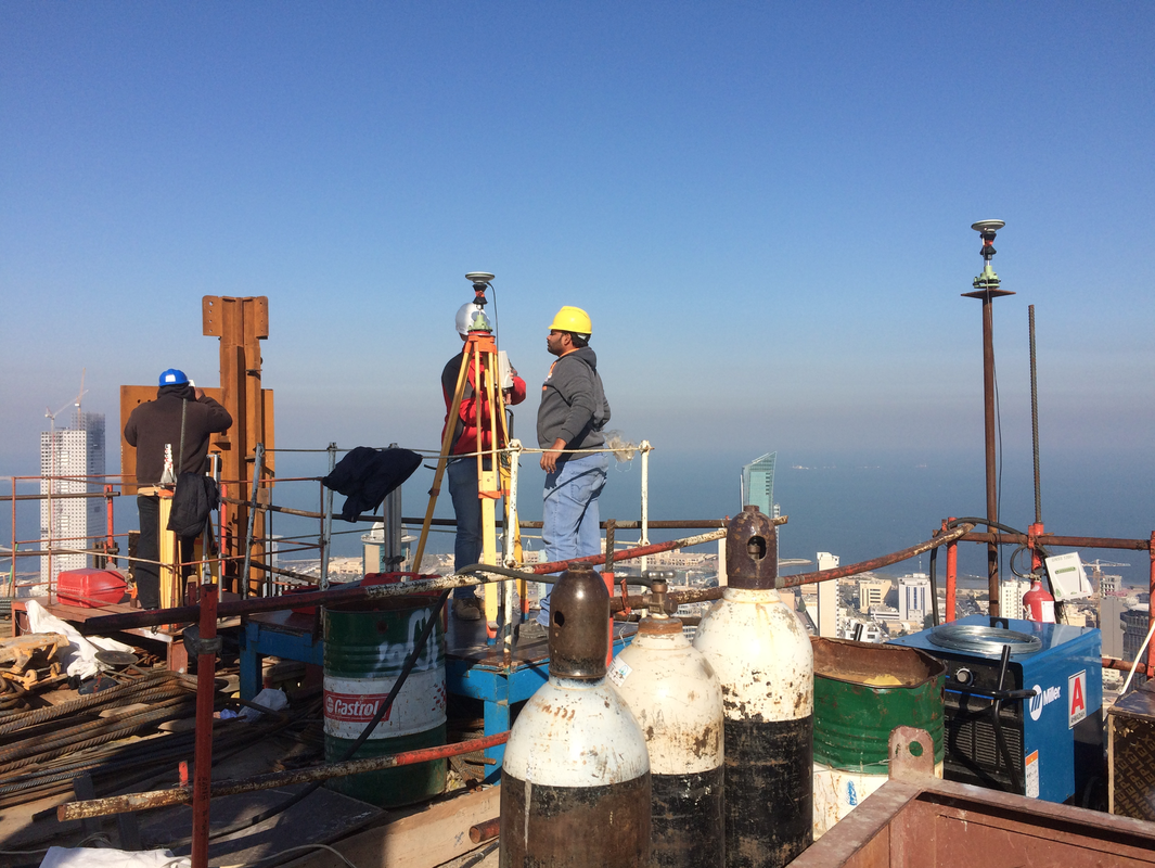
To guarantee the precise upward thrust of a tower along the vertical during construction, complete control must be maintained of the position of each new element erected on top of the existing core walls. Such new elements, and hence formwork structures, must be precisely positioned with respect to the main axis of the design reference frame, which is defined as the vertical positioned in the centre of tower. This means that the position of the formwork structures at the top of the tower must be continuously measured during erection of the building.
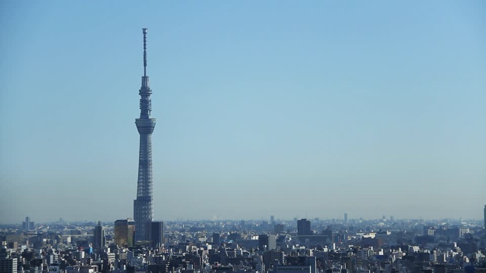
The coordinates, computed from the measurements, should refer to the main axis very precisely and reliably. However, anomalies arise from movement due to wind, cranes, sun radiation and other loads, and vibrations within the tower. Conventional methods for monitoring tall towers, such as optical plumbing, are incapable of compensating for such anomalies, and this is an intolerable drawback when the towers are super high-rise, such as the Burj Khalifa in Dubai. To control such towers, Joel van CRANENBROECK, Managing Director of CGEOS, developed and proof-tested a new measurement system based on GNSS (GPS and Glonass) combined with high-precision inclination sensors and total-stations. The surveying procedure, called Core Wall Control Survey System (CWCSS), has been applied first to the Burj Khalifa in Dubai, UAE, the Al Hamra tower and NBK tower in Kuwait, the Landmark tower in Abu Dhabi, the CMA tower in Riyadh, the New Lotte Tower in Seoul, the Skytree Tower in Tokyo, the Shard of Glass in London and other high-rise buildings around the world.
CGEOS - CREATIVE GEOSENSING has an unique expertise in leading super towers and other extreme engineering structures.
To guarantee the precise upward thrust of a tower along the vertical during construction, complete control must be maintained of the position of each new element erected on top of the existing core walls. Such new elements, and hence formwork structures, must be precisely positioned with respect to the main axis of the design reference frame, which is defined as the vertical positioned in the centre of tower. This means that the position of the formwork structures at the top of the tower must be continuously measured during erection of the building.
The coordinates, computed from the measurements, should refer to the main axis very precisely and reliably. However, anomalies arise from movement due to wind, cranes, sun radiation and other loads, and vibrations within the tower. Conventional methods for monitoring tall towers, such as optical plumbing, are incapable of compensating for such anomalies, and this is an intolerable drawback when the towers are super high-rise, such as the Burj Khalifa in Dubai. To control such towers, Joel van CRANENBROECK, Managing Director of CGEOS, developed and proof-tested a new measurement system based on GNSS (GPS and Glonass) combined with high-precision inclination sensors and total-stations. The surveying procedure, called Core Wall Control Survey System (CWCSS), has been applied first to the Burj Khalifa in Dubai, UAE, the Al Hamra tower and NBK tower in Kuwait, the Landmark tower in Abu Dhabi, the CMA tower in Riyadh, the New Lotte Tower in Seoul, the Skytree Tower in Tokyo, the Shard of Glass in London and other high-rise buildings around the world.
CGEOS - CREATIVE GEOSENSING has an unique expertise in leading super towers and other extreme engineering structures.
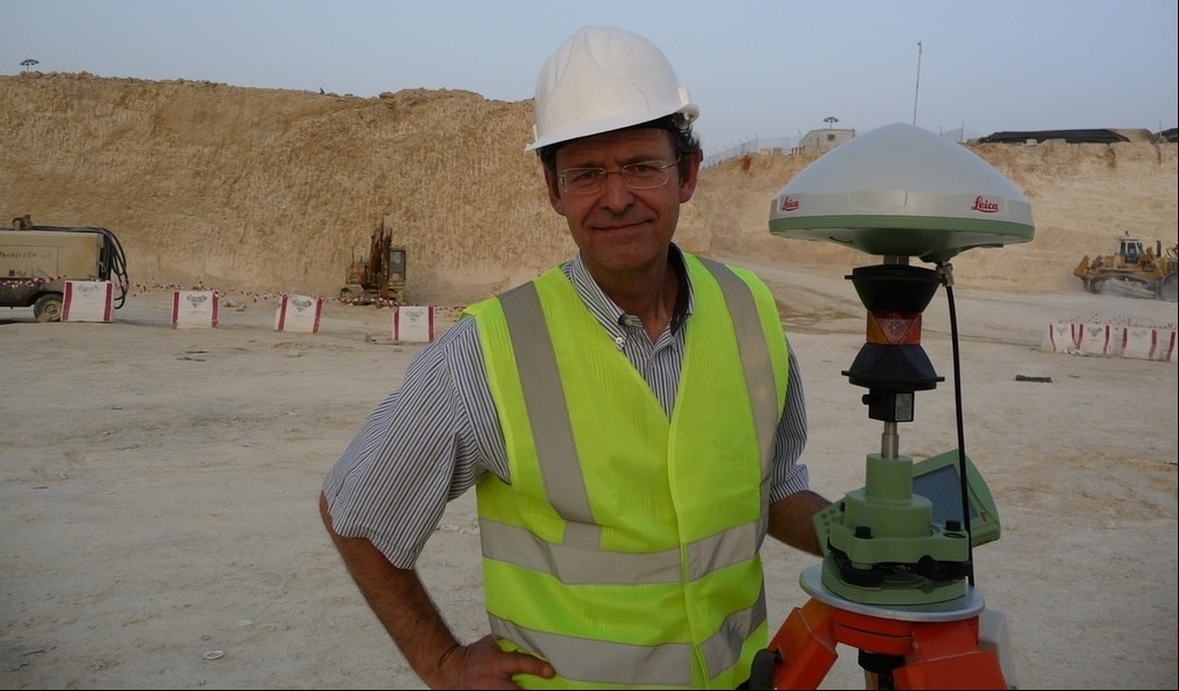
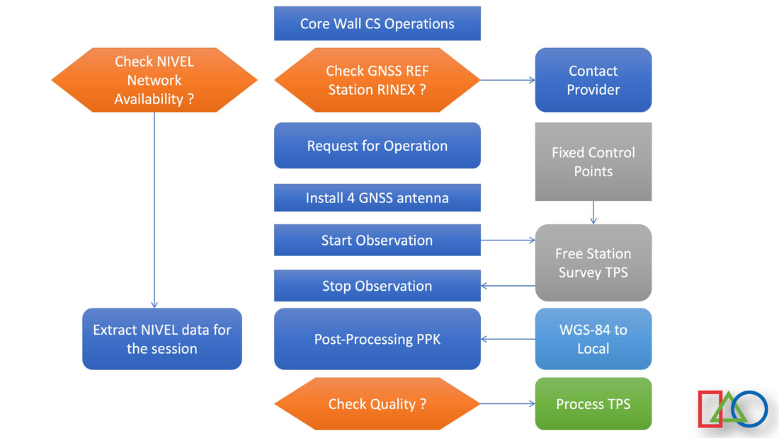
gnss at the highest accuracy on job site
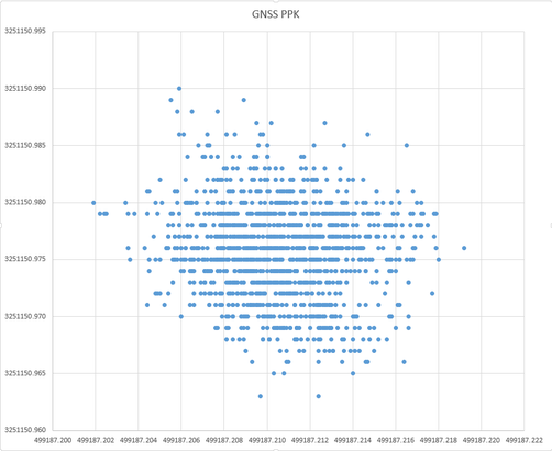
One of the key invention for succeeding with the CORE WALL CONTROL SURVEY SYSTEM has been to turn GNSS at its highest accuracy and on the job site. Confronting GNSS derived coordinates to accurate Total Station measurements is de facto proof checking this achievement. The "Active GNSS Control Points" approach is nowadays used everywhere in the industry.
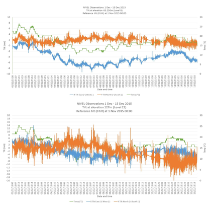
PRECISE DUAL-AXIS INCLINOMETERS NETWORKED
To align the coordinates obtained from the Total Stations, knowing the structure is subject to movements, swings and deflections, we are networking precise dual-axis inclinometers along the tower vertical axis. Calibration and dynamic modeling are part of the proposal.
|
|
Our proposal for high-rise buildings
|
Every high-rise building is unique as the wish of the owner to build unique iconic tower for leaving a footprint in a city landscape. Therefore all methods and systems for guiding the core walls along the true vertical must be adapted accordingly the structural brief, the construction sequences, the choice of the formwork systems and the environment.
Sometime, GNSS cannot be used due to the obstructions around the new construction and new approaches must be adopted. Interfacing surveying results with geotechnical instrumentation is also mandatory to understand the movements induce by the foundation load. All the information flowing in and out the designer and structural engineering office must be connected with BIM. Our proposal starts with developing method statements, primary survey control network, qualifying instruments and training the surveyors up to providing high qualified geodetic engineers to assist contractors during their work. |
|
|
|
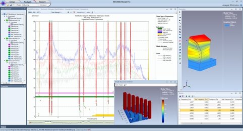
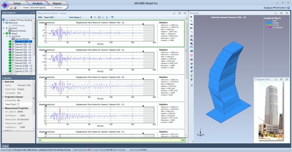
operational modal analysis
Another sequence is starting right after the construction and commissioning. It's about monitoring the new structure for at least 10 years corresponding to the contractor's responsibility. The merit of having already equipped an high-rise building with sensors (GNSS, inclinometers, automatic leveling systems ...) during the construction is to have the initial structural brief history. Adding accelerometers, velocimeters, anemometers and other dynamic sensors, will lead to provide operational modal analysis.
The Operational Modal Analysis is a method to describe a structure in terms of its natural characteristics that are the frequency, damping and mode shapes – its dynamic properties.
Methods of modal analysis are relatively recent methods of investigation, which have been implemented to establish and / or improve knowledge of the dynamic model of real structures. Indeed, the significant parameters making it possible to represent the dynamic behaviour of a linear structure whatever its complexity are "concentrated" in a number of reduced modal parameters: eigen frequencies, damping and associated eigenforms.
We are partnering with international experts who have long track record of project, developing and using dedicated softwares.
|
|
NATIONAL BANK OF KUWAIT TOWER
CGEOS has been the consultant for the contractor Ahmadiah to provide equipments, softwares and method statement for leading the core walls vertical.The challenge with that structure is that the core walls have been erected a bit bending in order to retrieve its verticality after the steel structure loads. CGEOS also provided the long term monitoring system using GNSS high precision and dual axis inclinometers networked. CGEOS developped an unique and orginal procedure to track the behavior of the main axis using least squares adjustment techniques.

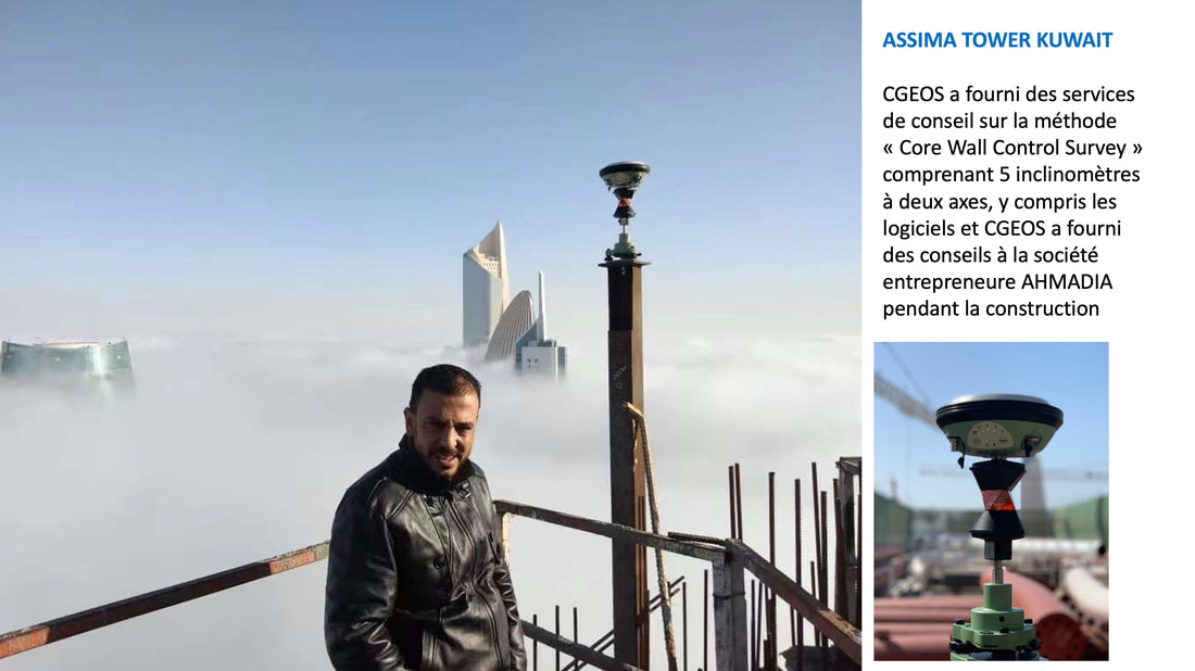
ASSIMA TOWER IN KUWAIT
CGEOS has been the consultant for the company Ahmadiah to provide equipments, softwares and method statement for leading the core walls vertical. The ASSIMA tower has been erected perfectly and now is part of the Kuwait city landmark.
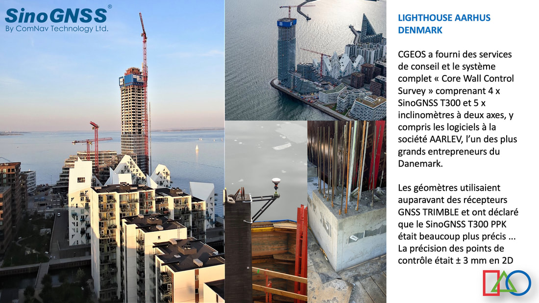
LIGHTHOUSE TOWER AARHUS DENMARK
CGEOS has been the consultant for the company L24 to provide equipments, softwares and method statement for leading the core walls vertical. An unique application has been delivered to update the coordinates of the Total Station operating on the plateform top taking into account the adjusted values of the dual axis inclinometers network.
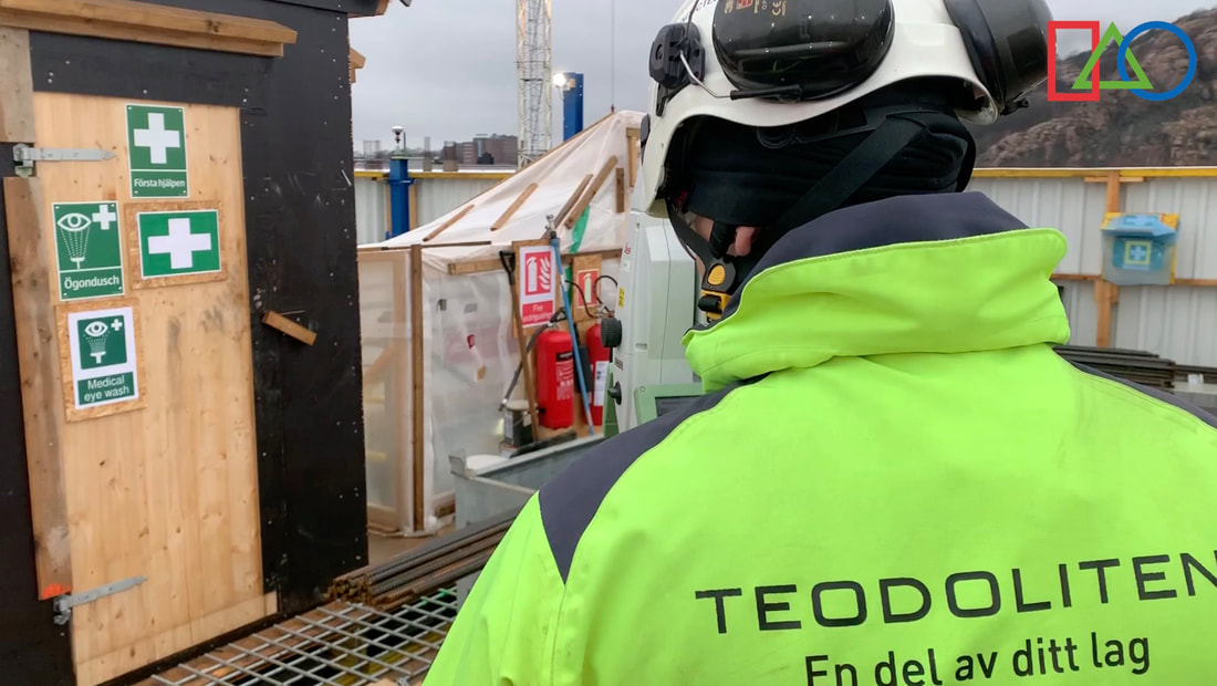
KARLA TOWER GOTEBORG SWEDEN
CGEOS has been the consultant for the company TEODOLITEN to provide equipments, softwares and method statement for leading the core walls vertical. Probably the most accurate surveying results were obtained at that tower by qualifying and following up the surveying engineers team on site.
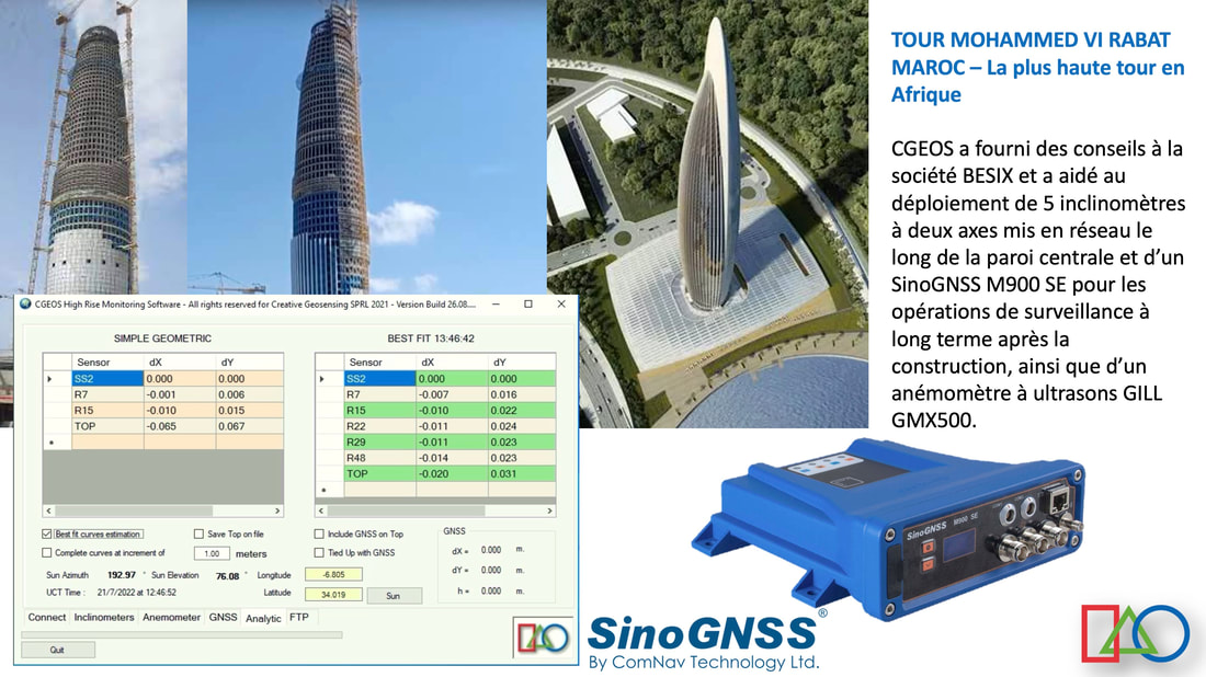
MOHAMMED VI TOWER RABAT KINGDOM OF MOROCCO
CGEOS has been the consultant for the company BESIX to provide equipments, softwares and method statement for leading the core walls vertical.

|
CREATIVE GEOSENSING SRL
Rue du Tienne de Mont, 11 5530 MONT, YVOIR (NAMUR) Belgique, Europe Tel. +32 (0)81 41 36 57 Mobile. +32 (0)474 98 61 93 [email protected] |
|
Latitude 50°3525804 North
Longitude 4°8918235 East Altitude 195 m. |
|
This site doesn't save any personal data in conformity with the RGPD in Europe
|
CGEOS Creative Geosensing (c) Copyright tous droits réservés 2024. CGEOS is a trademark.
|